


What Is GEOX AI? How GEOX AI is Transforming Military Intelligence and Modern Warfare
Udaipur, Apr 20, 2026: In an era where information dominance defines operational success, the ability to extract intelligence from every available source has become critical. One of the most powerful yet underutilized sources of intelligence is visual data images and videos shared across platforms every second. This is where GEOX AI, developed by TraceX Labs, introduces a breakthrough.
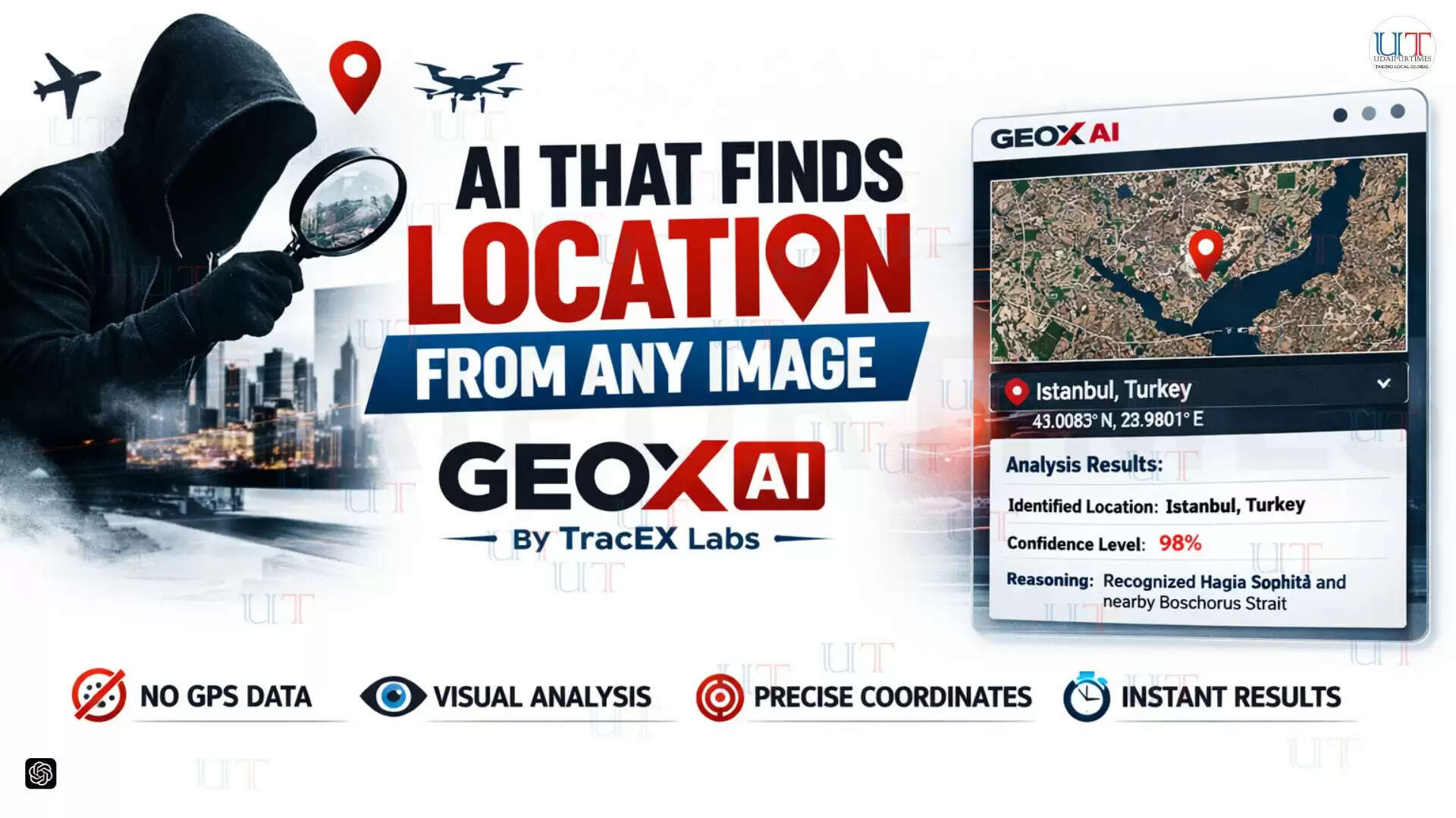
GEOX AI is an advanced artificial intelligence-powered geolocation intelligence platform capable of identifying the real-world location of an image or video using only its visual content. Unlike traditional systems that depend on GPS metadata, EXIF data, or embedded location tags, GEOX AI works purely by analyzing what is visible inside the media itself.
What Is GEOX AI?
GEOX AI is a next-generation geospatial intelligence (GEOINT) platform that uses computer vision and multi-agent AI systems to determine where a photo or video was captured. It examines pixel-level details such as:
- Architecture and building styles
- Road layouts and infrastructure
- Vegetation and terrain patterns
- Signage and language indicators
- Lighting, shadows, and environmental context
- Cultural and regional identifiers
By combining all these visual signals, GEOX AI can estimate and often precisely pinpoint the geographic origin of the media.
The platform delivers:
- Exact geographic coordinates
- Nearby landmarks or possible locations
- Confidence scores for accuracy
- Detailed AI reasoning explaining the result
- Interactive satellite map visualization
- Exportable professional intelligence reports
All of this is achieved in under 10 seconds for most analyses, making GEOX AI one of the fastest geolocation intelligence tools available today.
How GEOX AI Works
The system follows a streamlined yet highly sophisticated workflow:
- Upload any image or video frame
- The AI analyzes visual patterns, structures, and environmental cues
- Multiple AI agents evaluate possible matches across global datasets
- The system ranks potential locations based on probability
- Results are displayed on an interactive satellite map
- A detailed intelligence report can be exported instantly
Speed Meets Intelligence
GEOX AI is designed to operate in both rapid-response and deep-analysis scenarios:
Fast Mode
- Provides results within seconds
- Ideal for clear, high-context images
- Enables quick decision-making in real-time situations
Advanced Mode
- Performs multi-step, deep analysis
- Handles complex, low-context, or ambiguous visuals
- Delivers higher accuracy with detailed reasoning
This balance ensures that GEOX AI can adapt to both tactical field use and strategic intelligence operations.
Core Capabilities of GEOX AI
GEOX AI integrates multiple advanced intelligence features into a single platform:
Precise Geolocation Intelligence
Identifies exact coordinates using environmental and structural clues without relying on metadata.
Satellite Map Visualization
Displays results on live satellite maps with 2D/3D viewing options for better spatial understanding.
AI Reasoning Transparency
Provides a breakdown of how the AI reached its conclusion, improving trust and verification.
Multi-Result Ranking System
Returns multiple possible locations ranked by confidence for cross-validation.
Professional Intelligence Reports
Generates detailed PDF reports including maps, coordinates, analysis, and structured summaries.
Scalable and Enterprise-Ready
Supports hundreds of analyses per account, designed for agencies and large-scale operations.
How GEOX AI Can Help Military Intelligence
GEOX AI has significant implications for military and defense operations, where location intelligence is critical.
1. Battlefield Intelligence and Reconnaissance
Military forces can analyze images from drones, surveillance systems, or intercepted media to determine enemy positions, infrastructure, or movement patterns.
2. Open-Source Intelligence (OSINT)
Modern warfare heavily relies on publicly available data. GEOX AI enables analysts to:
- Verify images shared on social media
- Identify locations of conflict zones
- Track troop movements and equipment deployment
3. Counter-Terrorism Operations
GEOX AI can help identify:
- Training camps or hidden bases from shared media
- Locations of suspects based on visual clues
- Cross-border movement patterns
4. Target Verification and Mission Planning
Before executing operations, military units can use GEOX AI to:
- Confirm target locations
- Analyze surrounding terrain
- Understand environmental conditions
5. Disaster Response and Crisis Mapping
In military-led humanitarian missions, GEOX AI helps locate:
- Affected areas from images
- Survivors or stranded individuals
- Critical infrastructure damage
6. Surveillance and Intelligence Fusion
GEOX AI can integrate with existing intelligence systems to enhance:
- Satellite imagery analysis
- Drone reconnaissance data
- Multi-source intelligence fusion
Applications Beyond Military Use
While GEOX AI is highly valuable for defense, its applications extend across multiple domains:
- Law enforcement and criminal investigations
- Digital forensics and cyber intelligence
- Missing persons and search & rescue operations
- Journalism and fact-checking
- Threat intelligence and risk analysis
- Disaster response and crisis management
Performance and Scale
GEOX AI is built for high-performance environments:
- < 10 seconds average response time
- Up to 99% accuracy for landmark-based identification
- Global coverage across diverse terrains
- Multi-location prediction and ranking system
This makes it suitable for both real-time operations and large-scale intelligence workflows.
Privacy and Ethical Considerations
The capabilities of GEOX AI also raise important questions about digital privacy. By proving that location data can be extracted purely from visual elements, the platform highlights a critical risk:
Even without metadata, images can reveal location.
This has implications for:
- Social media users
- Journalists and activists
- Military personnel sharing media
- Organizations handling sensitive data
As such, GEOX AI not only serves as an intelligence tool but also as a reminder of the importance of visual data awareness.
The Future of Geolocation Intelligence
GEOX AI represents a major shift in how intelligence is gathered and analyzed. Traditional methods relied heavily on structured data, but modern systems like GEOX AI demonstrate that unstructured visual data can be transformed into precise, actionable intelligence.
As artificial intelligence continues to evolve, platforms like GEOX AI are expected to play a central role in:
- Autonomous intelligence systems
- Real-time battlefield awareness
- Advanced OSINT operations
- AI-driven decision-making frameworks
About TraceX Labs
TraceX Labs is a technology company focused on building advanced intelligence and cybersecurity solutions for agencies, investigators, and security professionals. The company specializes in transforming complex data into actionable insights using AI, computer vision, and geospatial intelligence technologies.
Conclusion
GEOX AI is more than just a geolocation tool it is a powerful intelligence platform that redefines how visual data is analyzed and utilized. From military intelligence to digital investigations, it provides a new level of speed, accuracy, and insight.
In a world where every image can hold critical information, GEOX AI ensures that nothing goes unnoticed.
#GEOXAI #TraceXLabs #ArtificialIntelligence #Geolocation #OSINT #CyberSecurity #IntelTech #AIInnovation #DefenseTech #ComputerVision #DigitalForensics #AIIndia #TechIndia #RajasthanTech #UdaipurTech #FutureOfAI #SmartIntelligence #GeoIntelligence #AIRevolution #SecurityTech